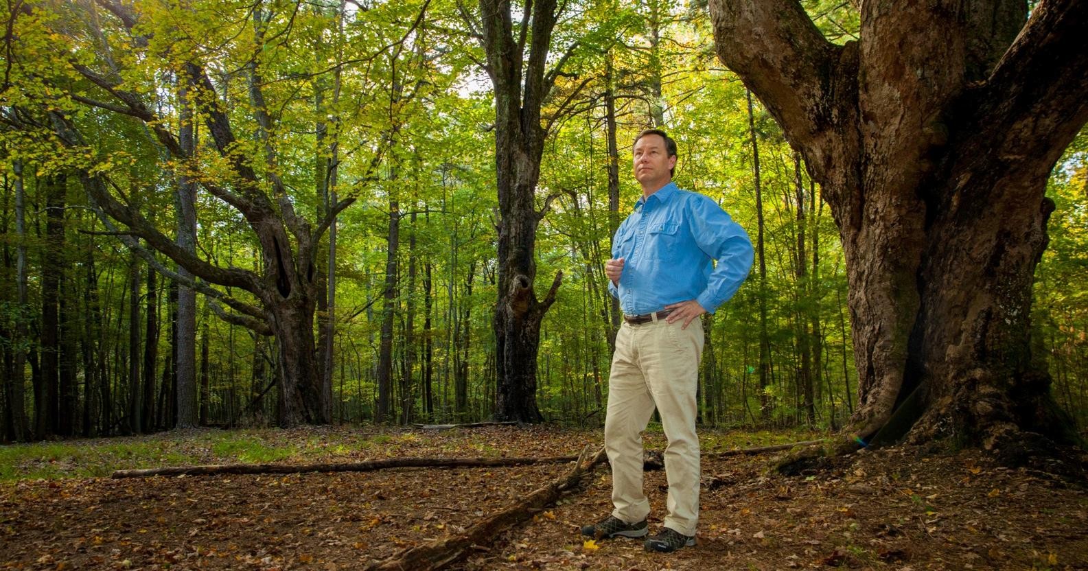
History Professor John Willis stands beneath the three towering sugar maples that likely shaded the farmhouse at King's Farm. Photo by Buck Butler
Domain Discoveries
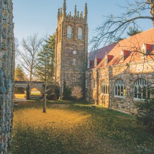
A Sewanee professor reads the landscape of the South Cumberland Plateau and finds its human history written—in the soil, on the rocks, and under the trees—just clearly enough to be legible.
BY JOHN C. WILLIS
I f he’s not in the classroom, in the University Archives, or at home, it’s likely that History Professor John Willis is in the woods. That’s where, for the last several years, he has spent countless hours, hiking trails and bushwhacking off-trail, in summer heat and winter ice, to research an environmental and social history of the South Cumberland Plateau. Unlike many historians, Willis conducts much of his research outside, with his eyes and his feet, trekking to seldom-visited tracts on and off the Domain to search for evidence of long-forgotten human activity. Willis reads the landscape like a ship’s captain reads the sea, like a rabbinical scholar reads the Torah—scanning for subtle variations in vegetation and telltale signs in the dirt. All that sweat and squinting has paid off with one discovery after another, giving the lie to the notion that these forests are largely untouched by human hands.
Here, Willis offers his take on five sites along Sewanee’s Perimeter Trail that you, too, can find, if you just look hard enough.
King’s Farm
Once you arrive, it’s easy to think the map is mistaken, until you see the sign: “King’s Farm.” And yet, there is no farm. Just a small clearing choked with weeds and three huge sugar maples arranged in an L pattern. No barn, no house, no fenced fields. Nothing that looks like a farm.
Then you notice that, while it’s not a farm, this is also not the sort of hardwood forest that grows throughout the rest of the Domain. Look back at those giant maples, defining three corners of a rectangle, their interlocking canopy stretching roof-like high above. It's not so difficult to imagine the house that must have been here beneath their branches, protected in the hottest months of the year by green leaves. This would have been one of the few shady places on the farm, because there are no other trees in view as thick or impressive as these maples. A farmhouse beneath shade trees, but the rest of the forest held at bay.
Now we begin to find signs of the farm where Isaac King and his family lived from the late-1930s to the late-1940s. Fruit trees grew a short walk from where the house stood; some of them (or their descendants) are there now. Farther along, black locust trees, which don't usually fare well in the thin, sandy Plateau soil, proliferate where the barn and chicken houses once spilled forth manure. We can find more clues: the well on the other side of the house site, some old empty bottles a little farther away, and the multiple sunken roads that led out to the place. With a little guidance and some extra information, we can “see” that a farm once stood here. I’ve benefitted from the knowledge and insight of colleagues from many departments, as well as members of the King family and others who grew up near here, who have helped me uncover the history of this area. They’ve shown me that the King’s Farm area contains several layers of history. The oldest layer we’ve found can be studied archaeologically, with the discovery of Native American tools and other artifacts dating back more than 9,000 years. There is also evidence of later Native Americans, possibly Cherokee, nearby. The next few layers date from the frontier period to the mid-20th century: a pile of foundation and chimney stones indicates a cabin from the 1850s; carvings in the bluff face reveal names of people who journeyed to this place from the valley below, from Sewanee, and from points as distant as Vicksburg, Mississippi, and southwestern Virginia; remnants of a fence line show where a Swiss immigrant established a boundary. The King’s Farm trail marker stands near the house site prepared by an ex-slave, Rufus Moseley, who bought the 103-acre farm from the Swiss immigrant, Christian Ruef. The King family lived in the house Moseley built and worked this land in the 1930s and 1940s, before the University turned it into a white pine plantation. Now it serves as a field site for research in biology, archaeology, geology, forestry, and history. It’s also a good place to hike and camp. Having glimpsed so many aspects of its history, I wonder how many more layers of the past might be hidden here, waiting to be discovered when we learn to better read the landscape.
Johnson’s Farm
To the west, at the far end of Breakfield Road’s gravel section, are some relatively recent additions to the Domain, areas added by gift or purchase in the 1950s and 1960s. South of that terminus, through Gate No. 9, a fire lane leads past the old Cheek Farm site (look for the yucca plants along the left side of the road) before it gives way to the bluff section where some of the sandstone for McClurg Dining Hall was quarried in 1997 and 1998. When resting from their labors, the stonecutters often searched with success for spear points and arrowheads left behind centuries before.
But it’s the opposite direction that usually attracts my attention. From the end of the road, I walk through Gate No. 8 toward Dotson Point, bound for the Domain’s northwestern extension. In the winter, when the trees and bushes are bare of leaves, you can see several sunken roads and paths leading off on each side of the fire lane. The road to Martin Johnson’s place, however, is in clear view any time of the year—on the right side of the fire lane about 100 yards from the gate. Johnson filled a number of roles at the University while his uncle, Benjamin Finney, was vice-chancellor (1922-1938). Sewanee ATOs owe Johnson their gratitude: He was responsible for the iron fences surrounding the maples in front of their chapter house. Johnson also provided the original decorative iron gate at the pavilion near the gardeners’ plots at the University Farm. After Finney’s tenure as vice-chancellor ended, Johnson leased and operated the Farm, until the University abruptly took back management in 1944.
On the left, a few hundred yards from the intersection with the old road to Johnson’s farm, we approach an unusual section of bluff. It’s the most recent major portion to collapse away from the Plateau. In Sewanee Perspectives, Geology Professor Bran Potter described what happened that day in 1994: A bluff section more than 100 feet long fell with such force that the forest floor below liquefied and surged down the slope, shooting pillars of fresh earth up to six feet high over 60 feet from the fallen rock. I wish I’d seen that.
Several years ago I explored the area where those huge bluff stones—some nearly as big as houses—fell. None of the statues of once-liquefied earth remained. Being younger then (and much more foolish), I thought I’d climb to the top of the Plateau from the terrace below along one edge of the fall area. The colluvium was still loose in places, it turned out, and for the last 12 to 15 feet I had to scale the exposed roots of a bluff-edge chestnut oak. Only on reaching the comparative safety of the top did I realize how near my weight had come to toppling the tree, and me, over the side. Now when I visit this area, I just sit on a sandstone outcrop near the bluff and admire the valley stretching away to the north. I’m always relieved to see that chestnut oak still hugging the Plateau edge.
Cherry Point Road
When you get back on Breakfield Road, return to the part of Sewanee most of us find more familiar. Once you reach the connector trail that runs underneath the water tower, follow it northeast toward the Perimeter Trail. After a couple hundred yards in the forest, you’ll descend to a wooden bridge. In summer, the bridge is surrounded by a beautiful fern gulley. Continue on the trail another hundred yards or so until you reach the apex of this section; to your left, you’ll notice a faint trail forking away to the west. Follow it.
I wandered along this path before the connector trail existed. I found it one winter when I was looking for breaks in the tree canopy—openings that might indicate a trail, a former house site, a clearing, or some other change in the forest that might have resulted from human activity. Walking about 100 yards along this path will bring you to a surprising site: a sunken road. Old maps of the Domain told me it dated from the 19th century. Following its course helped me understand its use. This road led to another one descending the Plateau from Cherry Point, offering access from the Domain to the area around Alto and points beyond.
In the process of tracing this road to Cherry Point, I realized it is possible to follow a Plateau-top dirt road with your eyes closed. You don’t need to see the road because you can feel it underfoot. The thin topsoil and the sandstone below were compacted as travelers and vehicles used the road, and rain thinned the soil along the roadway even more. Decades after this thoroughfare was last used on a regular basis, that eroded and compacted soil still proves unwelcome to native hardwoods. So, while mountain laurel and brambles will sometimes close off small portions of these old roads, they’re still easy to find: harder underfoot than the leaf litter they pass through, sunken from compaction and erosion, and usually clear of trees. Once I started noticing them, I found dirt roads and cart paths in profusion throughout the western portion of the Domain. Usually, my eyes were open during these discoveries.
Coal Nuggets and Chimney Stones
I was tracing one of the cart paths connected to the Cherry Point Road when I stumbled over an even more curious set of discoveries: old house sites, sandstone quarries, coal transfer areas, and lots of Native American weapons in an area bounded on the west by the creek flowing down from Cedar Hollow Lake. Many of these signs of long-past human activity are visible from the Perimeter Trail. The coal transfer point is the easiest to spot. Heading west on the trail, the path descends a couple of feet and you can’t help but notice coal nuggets on both sides. Students working with environmental studies faculty discovered that some of the coal is piled more than a foot deep. Thanks to their field work, I’ve been able to pinpoint the mines it was taken from about 60 feet below the bluff. Rather than haul their coal downhill over bumpy roads—and risk breaking the fuel into smaller and less valuable fragments—mine contractors moved it to the top of the bluff. Sometimes pulley systems were employed in this stage of transport, though I’ve found one contract in the University Archives allowing a contractor to build an incline railway to handle this work. Once on top of the Mountain, it was transferred into wagons and hauled out along the dirt paths and roads I’ve been mapping.
Another discovery in this area is also bisected by the Perimeter Trail. The pathway cuts through stones and bricks from a fallen house chimney. An archaeology team examined the area nearby and dated the structure from before the Civil War. In other words, the house these chimney stones served was standing before the University opened. Looking more broadly in the same area, archaeologists have used shallow excavations to locate stone hammers, spear points, chert knives, and other Native American artifacts. Not too far away, I found a fist-sized chunk of chert (a cousin of flint) and a 19th-century harness hook lying on the top of the ground near each other. Each was less than 10 yards from a cart path used to haul coal. It’s curious to ponder: A Native American centuries ago, a teamster just over 100 years past, and I all happened along the same way, if for very different reasons over a long space of time. Now people on the Perimeter Trail hike by this spot every day.
Knight’s Folly
The most surprising discovery I’ve made about the Perimeter Trail doesn’t spring from direct observation, but from more traditional historian’s work in the Archives. There, reading through the correspondence of Vice-Chancellor Bishop Albion W. Knight, I encountered what Robert Frost described as “the road not taken”—one I’m glad Sewanee did not venture along.
Soon after Frost published that poem in 1916, the University of the South found itself in dire financial straits. Rapid expansion at the turn of the century (with the opening of schools of law and medicine), led to sudden contraction after the recession of 1907. Construction of All Saints’ Chapel ground to a halt, and the law and medical schools were closed. Europe’s plunge into the Great War added uncertainty to many futures, and Sewanee’s all-male student body soon began to leave the school for the “war to end wars.” Even after the conflict ended, Sewanee’s debt was large, and the vice-chancellor announced a “Million Dollar Campaign” to raise funds that would set the institution on a more prosperous footing. A rapid infusion of cash was needed.
The University greatly expanded coal mining on the Domain during the war, charging mining contractors a royalty fee for the privilege of removing Sewanee coal. Then, someone wondered if there might be other fuel reserves below the veins of coal. This is how an Oklahoma oil man, Col. Jake L. Hamon, came in contact with Sewanee in 1920.
Few today have heard of Jake Hamon, but he was well known in his time. In June 1920 he was considered for the Republican presidential nomination. On the first ballot at their Chicago convention, he was among those receiving votes for the honor of leading the party. True, he was 10th on the first ballot, but eventual nominee Warren G. Harding was only seventh at that stage. Yet it was Hamon’s reputation for bringing oil wells into production and not his political prowess that explained his fame. Working through an intermediary in Oklahoma, and in contact with Tennessee’s state geologist, Hamon agreed to consider drilling for oil on the Domain.
It is a measure of the University’s financial desperation that negotiations continued even after Hamon’s fee of $50,000 per test well was disclosed. At this time, $50,000 represented between one-quarter and one-third of the University’s annual income, and the school routinely ran up to $20,000 in the red each year. But Vice-Chancellor Knight continued to encourage Hamon to come to Sewanee and proceed with the work, despite the high charge for his wildcatting services. Knight seems to have focused on the royalty income the school might receive from a successful well, rather than worry about the high cost of discovery.
The drilling site identified by State Geologist Wilber Nelson was in Shakerag Hollow, on University land below where the Perimeter Trail crosses Roark’s Cove Road today. Nelson was confident that oil would be found, predicting in a letter to Hamon’s go-between that “a test well drilled in this cove should not have to go over 600 to 700 feet in depth.” Although Hamon had to make a trip to examine oil properties in Wyoming before traveling to Tennessee, University officials were told to expect the “oil king” the week of Dec. 6, 1920.
But Jake Hamon never made it to Sewanee. He was shot by his longtime mistress and died five days later. Instead of welcoming Hamon and hoping for the success of his exploration in Shakerag Hollow, Vice-Chancellor Knight was left to inform governing board members of the shocking news, and to implore them to seek out other oilmen who might undertake the work in Hamon’s stead. Some of those board members had already heard the news by the time Knight’s letters arrived. The New York Times and other dailies gave prominent space to the lurid story of the rich man’s murder in Oklahoma and his mistress’s subsequent arrest in Mexico.
The University never found a wildcatter to take Hamon’s place and no test well was sunk. I’m glad no oil well—or more likely, the remnant debris from a failed rig—scars the Domain. Today’s Sewanee geologists assure me it would have been folly to drill where planned in 1920, and that the school would have been poorer by at least $50,000 if the work had proceeded. No flood of rich oil would have emerged to drown the University’s money troubles. In fact, there is good reason to wonder if the murdered Hamon was really an oil king, or just a fraud. Either way, Shakerag Hollow, where so many of us enjoy hiking, looking at wildflowers, and admiring the great trees and imposing bluffs, escaped drilling. Vice-Chancellor Knight was not so fortunate. The University’s continued financial difficulties led to his forced resignation just over a year later.
Most mornings find me walking with camera or notebook in hand through some part of the Domain. This activity has become more than just exercise, it also brings me meditation, art, research, and physical therapy. I don’t have to walk far from my home to enjoy this time in the woods or along the bluff, and I know I’m fortunate to be able to reach such remarkable spaces so easily.
What I’m searching for each morning is an encounter with the unfamiliar, the unpredictable, or the unexpected, and I frequently find just that. I want something to wonder at when the day is new: an old chert tool in the middle of a well-traveled path, strange metal debris almost covered by mountain laurel, a vague pattern of indicator species on the landscape. So many mysteries linking time and place surround us, waiting for our curiosity and ready for our attention. And in Sewanee we navigate among these possibilities while listening vaguely to the pileated woodpecker drumming at a hollow oak or sympathizing with the keening hawk as it calls for its mate.
We seldom know what we’re looking at, much less what we’re looking for in life. But the sorts of discoveries these five places have brought me in my walks along the Perimeter Trail are exactly what I’m after.
For their support, encouragement, and patience with this project, I want to thank David Coe, Jon Evans, Peter Garland, James Gipson, the late Marshall Hawkins, Martin Knoll, Karen Kuers, DebbieLee Landi, Patricia Short Makris, Chris McDonough, Greg Pond, Bran Potter, Steve Shaver, Sarah Sherwood, Jerry Smith, Ken Smith, the late Mae King Tatum, Chris Van de Ven, Laura Willis, and Nate Wilson.—John Willis.